


USNG 101: How to Use Locator Signs
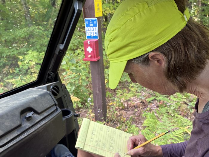
Have you noticed these signs around the Birkie Trail and Mt. Telemark Village and wondered, what do those numbers mean? These signs are not just a confusing set of characters; they provide valuable location information for emergencies and wayfinding. As a trail user, it is important to know how to read and utilize them.
The Birkie Trail and Mt. Telemark Village include emergency medical location signs that display United States National Grid (or USNG) locations. The USNG is a coordinate system that uses a grid to easily and quickly find and identify locations. This grid can be applied to GPS systems, as well as paper maps and Geographic Information Systems (GIS).
How do I use USNG signs on the Birkie Trail?
In the event of an emergency, if you are able, locate the nearest blue emergency location sign. These signs appear at nearly every Birkie trail intersection and road crossing, as well as on Trek Trails powered by OTM and the CAMBA mountain bike trail network, so that you’re never too far from an emergency location. You can share the number that appears on the sign with 911 or Birkie Medical staff, depending on the severity of your situation. Then, stay in the same place! It is imperative that you don’t move so that emergency responders can find your location quickly and easily based on your USNG coordinates.
You can find a complete map of USNG locator signs in Bayfield County here.
How do I read USNG numbers for wayfinding?
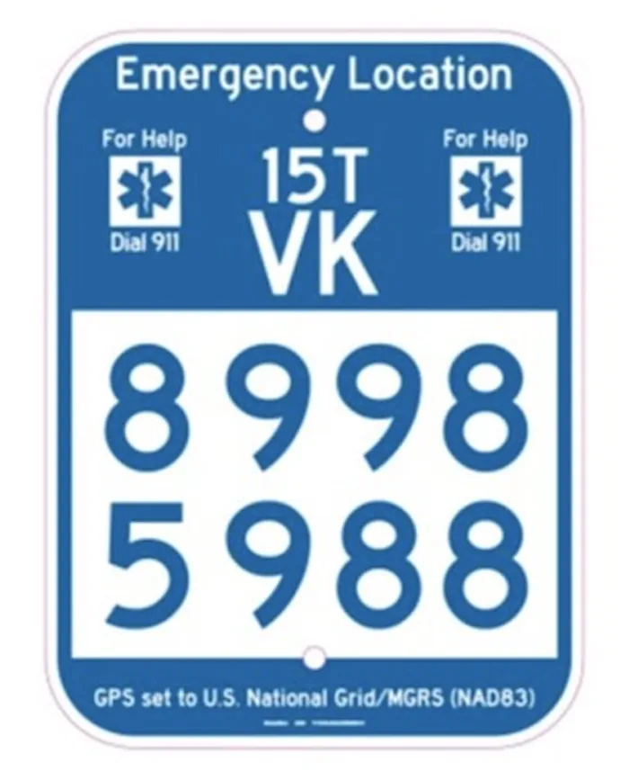
Let’s use this sign as an example. The first thing to know is that USNG numbers are “read-right-then-up,” where you read the grid numbers from the bottom left-hand corner going right to the first number, and then up the grid to the second number.
The smaller characters in white on this sign’s blue background (15T VK) are the Grid Zone Destination (GZD) and 100km Square Identification. If visualized on a map of the United States, we would read 15 gridlines right, and then up to grid T, showing us most of Wisconsin. In the 100km Square Identification, we would zoom in and read gridlines in alphabetical order until V, and then in alphabetical order up until K. This would show us regions in Wisconsin. The Birkie Trail intersects 3 different Square Indentification regions.
The next 8 numbers, shown in blue on the sign’s white background, are Grid Coordinates. This is how we are able to locate these signs precisely. Each number gives us increasing precision about where we are on the Earth’s surface. Note that when reading from a higher-precision orientation, numbers are truncated, so even though the first two digits is 89, we would truncate to 80. On this sign, then:
- Two digits locates a point within a 10km square (80 – truncated)
- Four digits locates a point within a 1km square (89 59)
- Six digits locates a point within a 100m square (899 598)
- Eight digits locates a point within a 10m square (8998 5988)
Therefore, this sign locates you in a specific 10m square on the Birkie Trail.
Why are these signs important?
USNG numbers are the preferred coordinate locating system for medical responders, including Birkie Med Friends. If you need medical attention on the Birkie Trail, you can be easily located by the nearest USNG signpost and help will arrive quickly.
Further, these signs provide wayfinding aid in weak or no cell signal. If you’re unsure of your location in the Wisconsin woods, you can use GPS apps such as MyUSNG for iPhone and Avenza Apps for Android. Note: these apps will need to be calibrated using a broadband or cell signal at first use, but then can be used in places where only Satellite connection is available, such as on the Birkie Trail.
Stay safe and happy trails!
Posted September 21, 2026 at 11:31 am


